Topography Matters: New Analytical Deformation Models Include Volcano Shape Parameters
Studying how volcanoes behave is key to understanding and anticipating their hazards. Signs of unrest — such as ground deformation, earthquake swarms, or flank movements — can be precursors to eruptions, but even when they pass without any major event, they provide valuable insights into the interior processes and stability of a volcano.
To capture these signals, scientists use monitoring instruments on land, at sea, and from space. The data reveal movements that may result from magma intrusions, pressure changes in a magma chamber, faulting, or sliding of unstable flanks. To trace such signals back to their sources, deformation models are run.
Most of these models, however, assume the volcano has a flat surface — a big simplification as real volcanoes, especially marine and island ones, have steep and asymmetric shapes. PRE-COLLAPSE PhD researcher Megan Campbell and co-authors now published the results from their study of analytical models that include realistic topography from the tip to the bottom of the ocean in the Journal of Geophysical Research: Solid Earth. “Real volcanoes — particularly marine and island volcanoes — have steep, asymmetric, and complex shapes. That complexity matters for deformation modelling,” Campbell explains.
This new approach not only improves source characterisation but also helps with an important problem: Where to best place monitoring instruments?
Modelling Deformation with Real Topography
Campbell built on a classification developed by fellow PhD researcher Elisa Klein, who used geomorphometric parameters to describe the shape of marine volcanoes. By testing how parameters like steepness, asymmetry, and ellipticity influence displacement in forward models, Campbell showed that “Topography matters and deformation doesn’t stop at the coastline.”
The steeper and more asymmetric a volcano is, the more important it becomes to include topography in deformation models. Significant ground displacement often occurs offshore — in zones invisible to traditional land-based GNSS monitoring networks.

70th, 80th, and 90th total displacement percentiles for El Hierro. The blue circles represent the permanent GNSS stations.
Case Study: El Hierro
One example is El Hierro, a volcanic island in the Canary Islands that had a submarine eruption in 2011. Using published seismicity data, Campbell simulated deformation during the eruption. Her results showed that most horizontal displacement occurred beneath the sea, concentrated in submarine embayments formed by earlier flank collapses. Yet, two of the island’s three permanent GPS stations lie outside these key displacement zones. Campbell emphasises: “Our study highlights the need for integrated monitoring — including offshore instruments — and shows how the design of future permanent networks could benefit from applying this approach.” To capture the full picture, monitoring must consider the whole volcanic edifice and its topography, from seafloor to summit.
“Our study highlights the need for integrated monitoring — including offshore instruments — and shows how the design of future permanent networks could benefit from applying this approach.”
Etna and Stromboli
Mount Etna was in fact the original motivation for this study. Rising from a submarine base 2000 m below sea level to more than 3000 m above, and with one flank extending into the sea, Etna’s massive structure makes it an ideal candidate for topography-informed deformation modelling.
The analysis also included Stromboli, another iconic Italian volcano. While it appears conical from above, its submarine flanks reveal a very different picture: Stromboli is the steepest and most asymmetric volcano in Campbell’s dataset.
Both examples underline the central message of the study: to understand volcanoes, we need to consider their entire shape — from the seafloor to the summit.
Megan’s research is part of the research project “DO VOLCANOES COLLAPSE REPROGRESSIVELY?” is supported by the Helmholtz Association of German research centres.

PhD researcher Megan Campbell

“Real volcanoes — particularly marine and island volcanoes — have steep, asymmetric, and complex shapes. That complexity matters for deformation modelling”

Axisymmetric (left) and asymmetric (right) depictions of a volcanic edifice. The axisymmetric cone is characterized by the height, H, the radius of equivalent edifice area, R and the elipticity, ei. The offset of the peak from the centroid is defined as ΔM.
The topographic asymmetry—especially in marine and submarine volcanoes—affects the magnitude and spatial distribution of surface displacements during volcanic activity.
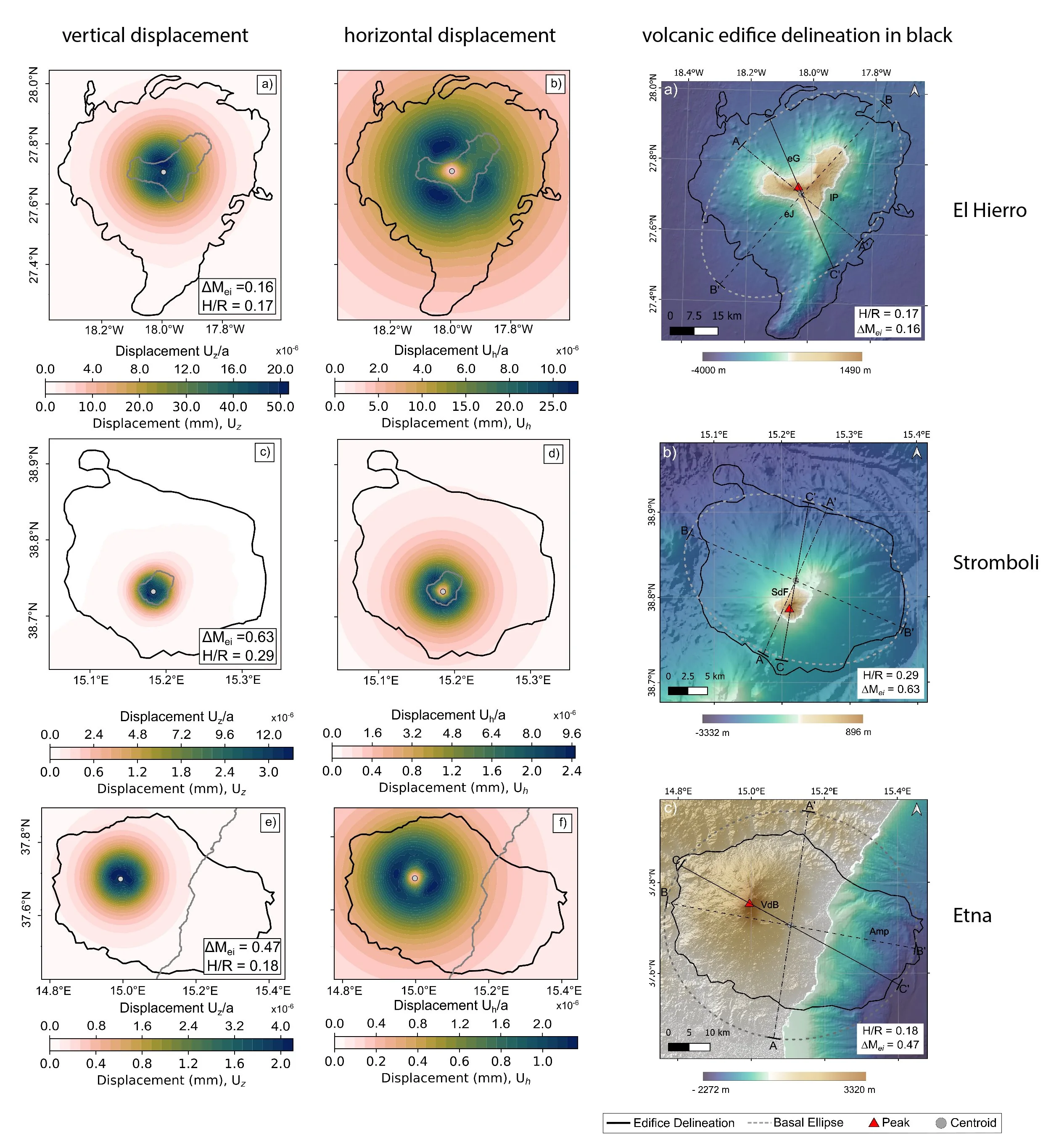
left: Displacements simulated for a literature-derived source of deformation for the case studies El Hierro, Stromboli and Etna. right: Case Study volcanoes with volcanic edifice delineations in black after (Klein et al., 2023). The red triangles (peaks) coincide with the source location in the models (on the left).
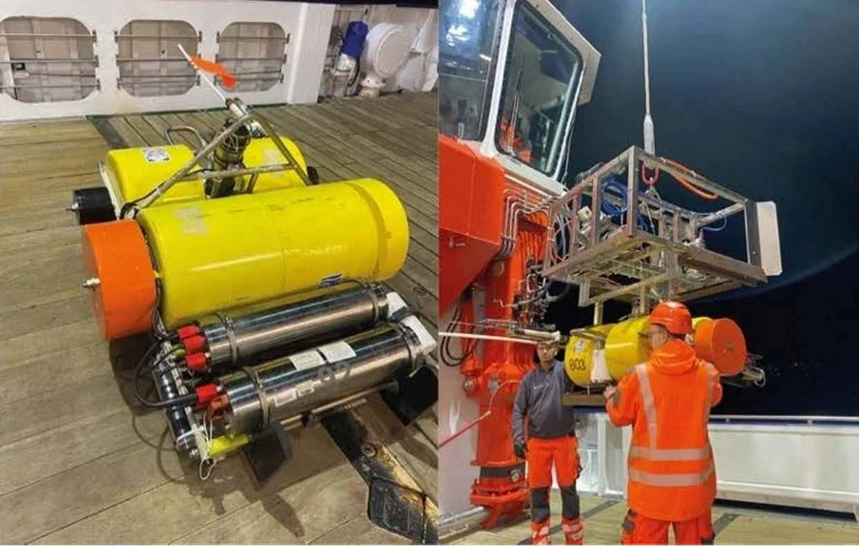
Ocean Bottom Seismometers (OBS) deployment on board of R/V MARIA S. MERIAN

Map of the Kolumbo submarine crater and other submarine cones on the north-east trending Kolumbo volcano-tectonic rift. (H. Sigurdsson, S. Carey et al.)
Using topography based deformation models to prepare for long-term monitoring experiment at Kolumbo submarine volcano
The method was also applied ahead of the Kolumbo research cruise with Research Vessel MARIA S. MERIAN in December 2024. Kolumbo is a submarine volcano near Santorini with a well-imaged magma chamber, known from seismic tomography. Because topography strongly influences how much displacement occurs and where it is expressed at the surface, Megan Campbell modelled the expected deformation patterns if the magma chamber were to inflate or deflate.
Her results guided the cruise team in selecting the best sites to deploy Ocean Bottom Seismometers (OBS) for long-term monitoring. Based on the modelling, several OBS instruments were installed inside the caldera, where any displacement would be most visible, and others along the flanks.
This turned out to be especially timely: only a few weeks later, in early 2025, the Santorini region experienced an intense seismic crisis with thousands of earthquakes. The new OBS network at Kolumbo is now ideally positioned to record such activity and shed light on processes driving seismic swarms in this highly active volcanic system.
Learn more about this volcanic area and projects:

Map showing the deployment locations during OBS Experiment 2 - long-term deployment.