Ocean Island Volcanoes
once erupted on the seafloor before their tops emerged above sea level. What is sticking out above the water is only a small portion of the whole volcanic edifice, similar to an iceberg.
Ocean Island Volcanoes are big and heavy. The material on which they are built, and which they are built from is very unstable. As long as they are volcanically active, volcanic islands grow rapidly and often on soft sediment. These sediments can become slippery and promote the movement of parts of the volcano.
As volcanic islands build up fast, they can also erode fast. Flanks of many volcanoes worldwide slide down gradually in the range of some centimetres per year, as documented by geodetic monitoring.
Such movements express structural instability:
Most volcanoes exhibiting slow flank sliding today have experienced flank collapses in the geological past.
Flank collapses
are large, rapidly sliding masses of rock. When they strike the water, the sudden displacement of huge volumes of water can generate a tsunami wave.
This happened in December 2018 when the volcano Anak Krakatau in Indonesia collapsed and caused a damaging tsunami. We also know from the geological record that many, if not all, ocean island volcanoes have a history of repeated flank collapses - over millions of years. Why and when these collapses happen is still poorly understood, leaving them yet unpredictable.
Onshore ground deformation analyses reveal signs of on-going flank instability at numerous coastal and ocean island volcanoes today. Volcanoes, including those in Hawaii, the Canary Islands, and La Réunion, are potentially liable to collapse. These types of events are usually difficult to predict as most of the sliding mass is below water level.

Stromboli (Italy) with the Sciara del Fuoco that was formed as a result of a sector collapse around 5,000 years ago. In December 2002, a sector collapse involving 17 million cubic meters of volcanic material, triggered an 8 metre high tsunami wave. (Image: Alfio Amantia, INGV)

Fogo (Cape Verde): After a sector collapse of the volcano about 70,000 years ago, a wave 170 metres tall slammed into nearby Santiago Island. (Image: Earth Observatory/ NASA)

Anak Krakatau (Indonesia) with products of its collapse in December 2018, situated in the centre of a crater that was formed during the eruption of the ancient volcano Krakatau. (Image: Copernicus Satellite, 2019)

Piton de la Fournaise (La Réunion) with the 4.5,000 years old elongated horseshoe-shaped collapse structure in which the currently active cone developed. (Image: Google)

Soufrière Hill (Montserrat, Lesser Antilles) and the deposits of the 1997 failure of the south-western flank that was the culmination of a devastating eruption 1995-1998. (Image: NOC)

Etna (Italy): The depression Vale del Bove was probably formed during a collapse about 10,000 years ago. (Image: Karen Strehlow)
Much bigger flank collapses
than the recent example of Anak Krakatau, are revealed by the geological records.
These three maps below are all at identical scale. The comparatively small collapse of Anak Krakatau involved only about 0.12 cubic kilometre of subaerial material - this would fill 5 times the worlds highest skyscraper Burj Khalifa-Compared to that, the Nuuanu volcanic landslide off Oahu, Hawai'i, moved about 5,000 cubic kilometre of rocks -these would cover France 10 m thick.
A collapse the size of Oahu is unlikely to happen within our lifetime but would have extreme and global consequences, particularly on our high-tech society.
In addition to the devastating Tsunamis that would destroy lives and infrastructure at the costs, the mass movement at the seafloor could also destroy seafloor telecommunication cables that underpin the internet.
Collapses of smaller island arc volcanoes - like Anak Krakatau - occur on average every 100-200 years.
Collapses of large basaltic volcanoes, such as the Canaries or Hawaii, are much less frequent. However, geological evidence is abundant that they occur and that they are devastating.
Image: USGS
The volcanoes do not stop at the shoreline
This relief map of the Hawai’ian Islands illustrates that large parts of the volcanic structures - as much as 85 percent- are under water! Here only the green coloured parts stick out as land surface. Measured from the ocean floor, Kilauea would be the highest mountain on earth.
Understanding slow flank movement to predict catastrophic collapse
It may become possible to say if and when a volcanic flank may collapse:
If we can identify and correctly interpret the dynamics of unstable volcano flanks!
To observe these slow volcanic flank movements, the deformation of the earth needs to be monitored.
We need to achieve this for the entire volcano above and below water.

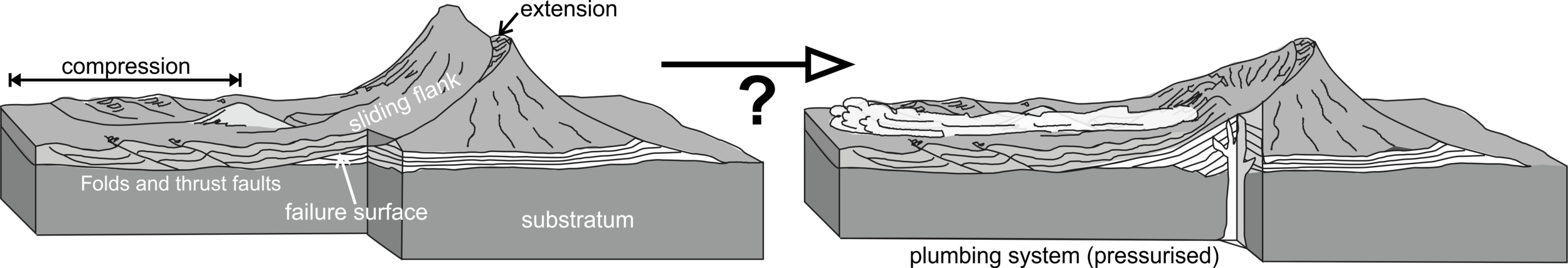
There are two possible physical explanation for slow flank movement and its transition to catastrophic collapse:
Slow sliding flank -> Edifice instability -> Collapse
Flank sliding alters the stability of the volcanic edifice by changing the rocks’ mechanical properties (strain-weakening material behaviour and/or formation of internal shear zones). This may either cause direct flank collapse or weaken the flank to an extent that an external trigger, such as an earthquake or rapid dike intrusions, can cause collapse.
Slow sliding flank/ Collapse <-> Magmatic plumbing system
Flank collapses cause changes in pressure conditions within the volcanoes’ magmatic plumbing system. This can for example cause the rapid rise of large amounts of magma.
In turn, large and rapid dike intrusions could cause horizontal acceleration of already unstable flanks leading to their collapse.